Bigger. Better. Safer.
Expanding the Houston Ship Channel is critical to safely and efficiently sustaining national energy security, domestic manufacturing growth, thriving U.S. exports, and expanding job opportunities.
It is one of the most vital waterways in the country, connecting the nation’s largest petrochemical complex to the globe. The waterway has more deep-draft ship visits than any other port in the country, and nearly 200,000 barge transits every year as well. As energy and manufacturing exports increase and vessel sizes grow, improving the channel is nationally important.
That national economic impact is significant: the Port of Houston drives $906 billion in annual national economic value, sustains more than three million U.S. jobs, and is the nation’s number one port in total waterborne tonnage.
About the Project
As the local sponsor of this crucial federal waterway, Port Houston is partnering with the U.S. Army Corps of Engineers to expand the channel.
The Houston Ship Channel expansion – Project 11 – is widening the channel by 170 feet along its Galveston Bay reach, from 530 feet to 700 feet and deepening some upstream segments to 46.5 feet, alongside other safety and efficiency improvements, and crafting new environmental features.
Dredging began in 2022 and with the help of our partners, we are expediting the process to complete the work in 2029. Overall, Project 11 is making the channel safer, ensuring this waterway will continue to remain the national economic treasure it is today.
Interactive Project Map
Learn more about the segments of the channel expansion project, the program’s environmental initiatives and the industry that comprises the Port of Houston.
You can find a static PDF map of the segments and our constructions progress here.
-
 Bolivar Roads to Redfish
-
 Redfish to Bayport Ship Channel
-
 Bayport Ship Channel to Barbours Cut
-
 Bayport Ship Channel
-
 Barbours Cut Ship Channel
-
 Boggy Bayou (BW 8) to Sims Bayou
-
 Sims Bayou to IH 610
-
 IH 610 to Turning Basin
-
 No work planned in these segments
The Houston Ship Channel Expansion — Project 11 has several environmental components. Click the icons on the map for details about these initiatives, including building new bird islands, marshes, oyster reefs, and providing air quality benefits. You can also learn more about Project 11’s environmental initiatives here.
-
 Marsh Creation
-
 Bird Island Construction
-
 New Oyster Reef
-
 Marsh/Bird Island Construction
-
 Air Quality Improvement
-
No work planned in these segments
There are more than 200 public and private facilities along the Houston Ship Channel. Roll over or click to see company names. Project 11 is reaching completion in collaboration and communication with many industry partners.
The interactive map above is for presentation and communication purposes only. It is not to scale. Port Houston does not assume liability for any damages caused by any errors, omissions or inaccuracies in the map or any data thereon or related thereto, nor as a result of the failure of the map or such data to function on any particular system. Port Houston makes no warranty, expressed or implied, including the warranty of merchantability or fitness for a particular purpose, accompanying this map or data. Users of the map and any related data are solely responsible for interpretations made therefrom. Please feel free to contact our staff if questions arise in the use thereof or in any of our products.
What is the “Texas Chicken” Maneuver?
This maneuver is unique to the Houston Ship Channel. Ships from opposing directions in the channel meet each other head-on but still safely pass each other, as hydrodynamic forces keep the vessels from touching! This maneuver is successfully performed every day, and it’s necessary in relatively narrow channels like ours. Even with the incredible skill this maneuver requires, there is no question that a wider channel is a safer channel.

The Houston Ship Channel Mega Study and Chief Engineer’s Report
Port Houston began planning the latest improvements to the Houston Ship Channel in 2010, working in collaboration with Congress, the Army Corps of Engineers and channel stakeholders.
With help from Port Houston, the Corps completed its five-year Project 11 feasibility study, the Houston Ship Channel Mega Study – the next navigation improvements to the Houston Ship Channel system. In April 2020, the Chief of Engineers signed the final Chief’s Report for the project. You can read the Chief’s Report here.
Water Resources Development Act (WRDA)
Congress schedules WRDA legislation for passage every two years to provide the Corps with direction on projects and policy in all of its mission areas, including navigation, flood control and environmental restoration.
The Houston Ship Channel Expansion Channel Improvement project was authorized in the Water Resources and Development Act of 2020 as part of a larger legislative package passed by Congress in December.
On January 19, 2021, the Port of Houston was notified by the U.S. Army Corps of Engineers (USACE) that it was awarded a “new start” designation and $19.5 million in federal funds to begin construction of the project.
Latest News
View Port Houston blog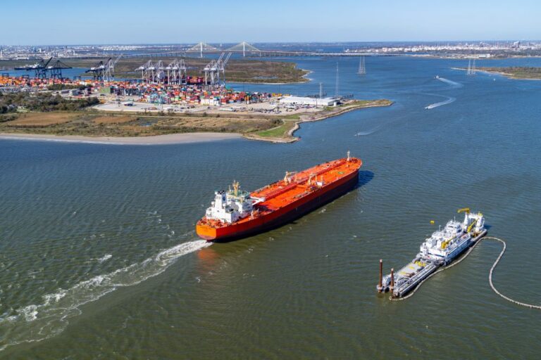


A Safer and More Efficient Channel
Contact Us